


دانلود آخرین نسخه کرک شده مادفلو GMS 10.4.7
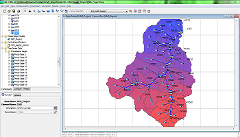
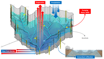
GMS Premium محصول شرکت کمپانی Aquaveo نرم افزاری با رابط کاربری گرافیکی و کاملاً قابل فهم است که قابلیتهای فراوانی را در زمینه مدلسازی و شبیهسازی سهبعدی آبهای زیرزمینی در اختیار کاربرانش قرار میدهد. مدلهای سهبعدی ساخته شده توسط این نرم افزار در واقع سیستم واقعی آبهای زیرزمینی را شبیهسازی میکند تا کاربر قادر به تجزیه و تحلیل، مدیریت و همچنین بررسی کنشها و واکنشها در یک سیستم هیدرودینامیکی باشد.
قابلیتهای کلیدی نرم افزار Aquaveo GMS Premium:
- مدلسازی و مصورسازی آبهای زیر زمینی
- تحلیل و بررسی مناطق جغرافیایی آبخیر
- طراحی مدلهای سه بعدی مناطق آبی
- تحلیل سیستمهای هیدرودینامیکی
- مدیریت و کمترل پروژههای آبی و هیدرولیکی
Aquaveo GMS (Groundwater Modeling System) Premium is the most intuitive and capable software platform used to create groundwater and subsurface simulations in a 3D environments.
“I’ve used GMS for over 15 years on a wide variety of modeling and visualization projects. The conceptual model approach/tools and continuing improvements to the software allow me to efficiently develop cost-effective models for clients who are always concerned about their budget. The Aquaveo development team is very responsive to questions/suggestions and the online discussion group is a great forum for both users and developers...”
Speed up & simplify model building with the conceptual model approach in GMS:
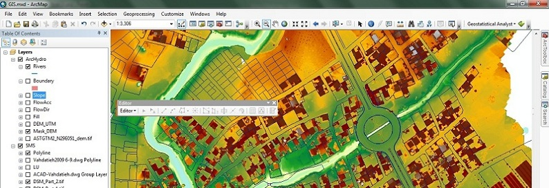
We pioneered conceptual modeling and have refined it over many years. That's why GMS is the quickest and most intuitive groundwater modeling interface available. Construct a high level representation of the model using familiar GIS objects: points, arcs and polygons and easily update the model as needed.
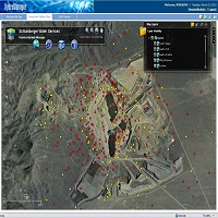
3D visualization optimized for performance:
GMS is the most advanced software system available for performing groundwater simulations in a three-dimensional environment.
- Interact with models in true 3D
- Optimized OpenGL graphics for improved hardware rendering
- Create photo-realistic renderings
- Generate animations for PowerPoint or web presentations
- Drape images over the model and control the opacity
- Annotations – Add north arrows, scale bars, reference images, company logos, and more
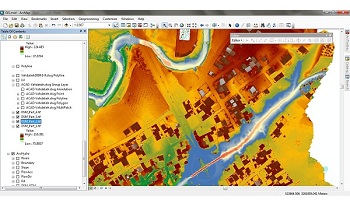
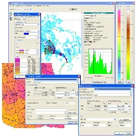
Import a variety of data formats & imagery:
Models require data from many different sources. That’s why GMS is built to easily import numerous file types:
- Raster images including georeference and projection support
- Topographical maps & elevation data
- Borehole data including stratigraphy and geophysical data
- Native MODFLOW files
- MODFLOW files from Visual MODFLOW, Groundwater Vistas and PM Win
- Web data services such as TerraServer
- ArcGIS geodatabases and shapefiles
- CAD files including .dwg, .dgn, and .dxf formats
- Worldwide projection support including Cartesian and Geographic Systems
- File Import wizard for delimited text files and spreadsheets
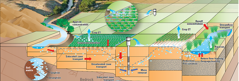
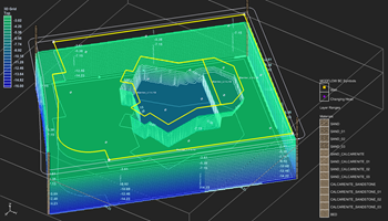
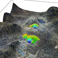
Advanced subsurface characterization:
From cross-section editing to advanced probability statistics, GMS offers unparalleled subsurface modeling tools.
- Generate iso-surfaces from 3D data to visualize plumes
- Cut cross-sections anywhere through 3D data
- 2D & 3D geostatistics – Kriging, IDW and Natural Neighbor
- Robust and fast algorithms to create solids from horizons
Software from an Industry Leader:
GMS is developed by Aquaveo, an engineering services company with many years of experience developing groundwater modeling solutions.
- Step-by-step tutorials and how-to videos
- Online community forum and product documentation
- Phone and email technical support
- Regularly scheduled training courses taught by expert modelers
- On-site training available
- Professional consulting services
سیستم مورد نیاز
- Operating System: Windows 7, Windows 8/8.1 or Windows 10
- RAM: 4 GB (8GB or more recommended)
- CPU: GMS software is CPU intensive. Some models and utilities integrated with GMS can take advantage of multiple processor cores simultaneously. We recommend the fastest CPU your budget allows.
- Graphics Card: For all display features to be enabled, OpenGL 1.5 or higher must be supported. The use of a dedicated graphics card is strongly recommended. Integrated graphics cards are often problematic.
- Display Resolution: 1920 x 1080 or greater
مشخصات
شرکت سازنده: آکواوئو / Aquaveo, LLC Link to
نام انگلیسی: Groundwater Modeling System
شماره نسخه: v10.4.7 x64
نام فارسی: جیاماس پریمیوم
قیمت: 12400 دلار آمریکا (صرفاً جهت اطلاع)
حجم فایل: 847 مگابایت
تاریخ انتشار: 01:10 - 1398/10/8 | 2019.12.29
امتیاز: 4.5 Star(s) 4.5/5
راهنمای نصب
1. ابتدا نرم افزار را دانلود و از حالت فشرده خارج نمایید.
2. با اجرای فایل Setup.exe نرم افزار را نصب کنید.
3. وارد پوشه Patch شده و بر روی فایل Patch.exe کلیک راست نموده و Run as Administrator را بزنید.
4. در پنجره باز شده گزینه Patch را بزنید.
5. برای فعالسازی تمام قابلیتهای نسخه Premium بعد از باز نموده نرم افزار از منو Edit گزینه Model Interfaces را انتخاب کرده و سپس تیک گزینه All را بزنید.
6. نرم افزار کاملاً فعال شده و بدون هیچ محدودیتی قابل استفاده است.
نکات:
- این نرم افزار کاملاً تست شده است.
- این نرم افزار فقط بر روی سیستمهای 64 بیتی نصب و اجرا میشود.
- تمامی فایلها تا حد ممکن فشرده شده و قابلیت تعمیر توسط WinRAR را دارا میباشند.

برای یافتن تمامی مطالب مرتبط با این مطلب در سایت از جستجوی سایت در حاشیه سمت راست و بالای صفحه استفاده فرمایید.

ورود به بخش آموزش های متنی GMS


دانلود آخرین نسخه نرم افزار GMS

دریافت لایسنس ارزیابی (14 روزه)

برای سفارش انجام مدل سازی اینجا کلیک کنید

مدیر سایت: بهزاد سرهادی کارشناس ارشد مهندسی آب
شناسه تلگرام مدیر سایت: SubBasin@
نشانی ایمیل: behzadsarhadi@gmail.com
(سوالات تخصصی را در گروه تلگرام ارسال کنید)
_______________________________________________________
پروژه تخصصی در لینکدین
 در منابع آب


نظرات (۰)