آموزش نحوه ساخت منحنی حجم - ارتفاع دریاچه یا مخزن با پایتون
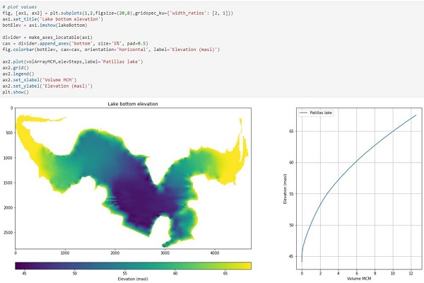
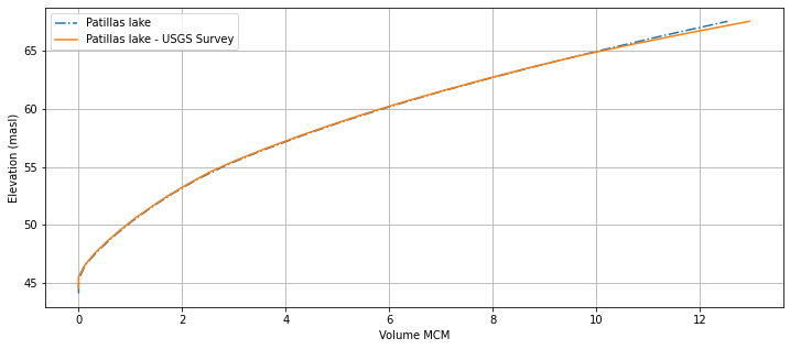
Python یک زبان برنامه نویسی است که قادر به انجام محاسبات برای مطالعات هیدرولوژیکی و ارزیابی منابع آب است. ما یک آموزش برای تعیین منحنی حجم و ارتفاع دریاچه پاتیلاس در پورتوریکو با پایتون و کتابخانه های عددی / مکانی به عنوان Numpy و Rasterio انجام داده ایم. سرانجام، نتایج به دست آمده از منحنی حجم و ارتفاع از یک منبع USGS مقایسه شد.
این روش این بار برای یک دریاچه انجام شده است، اما هنگامی که سطح زیرین به عنوان یک پرونده رستری در دسترس باشد، می توان آن را به راحتی در هر مخزن یا بدنه آب اعمال کرد.
کد پایتون:
#Import required libraries
import rasterio
import numpy as np
import pandas as pd
import matplotlib.pyplot as plt
from mpl_toolkits.axes_grid1 import make_axes_locatable
Open raster file
lakeRst = rasterio.open('../Rst/lakeBottomElevation.tif')
lakeRst.count
1
#raster resolution
lakeRst.res
(0.5, 0.5)
#all raster crs info
lakeRst.crs.wkt
'PROJCS["NAD83(2011)]'
Get raster values as Numpy array
lakeBottom = lakeRst.read(1)
#raster sample
lakeBottom[:5,:5]
array([[-3.4028235e+38, -3.4028235e+38, -3.4028235e+38, -3.4028235e+38,
-3.4028235e+38],
[-3.4028235e+38, -3.4028235e+38, -3.4028235e+38, -3.4028235e+38,
-3.4028235e+38],
[-3.4028235e+38, -3.4028235e+38, -3.4028235e+38, -3.4028235e+38,
-3.4028235e+38],
[-3.4028235e+38, -3.4028235e+38, -3.4028235e+38, -3.4028235e+38,
-3.4028235e+38],
[-3.4028235e+38, -3.4028235e+38, -3.4028235e+38, -3.4028235e+38,
-3.4028235e+38]], dtype=float32)
#replace value for np.nan
noDataValue = np.copy(lakeBottom[0,0])
lakeBottom[lakeBottom==noDataValue]= np.nan
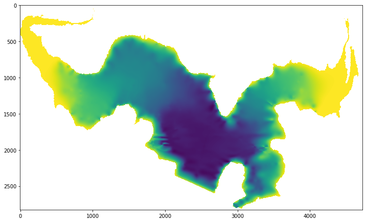
plt.figure(figsize=(12,12))
plt.imshow(lakeBottom)
plt.show()
Lake volume calculation
# get raster minimum and maximum
minElev = np.nanmin(lakeBottom)
maxElev = np.nanmax(lakeBottom)
print('Min bottom elevation %.2f m., max bottom elevation %.2f m.'%(minElev,maxElev))
# steps for calculation
nSteps = 20
# lake bottom elevation intervals
elevSteps = np.round(np.linspace(minElev,maxElev,nSteps),2)
elevSteps
Min bottom elevation 44.10 m., max bottom elevation 67.55 m.
array([44.1 , 45.33, 46.56, 47.8 , 49.03, 50.27, 51.5 , 52.74, 53.97,
55.21, 56.44, 57.67, 58.91, 60.14, 61.38, 62.61, 63.85, 65.08,
66.32, 67.55])
# definition of volume function
def calculateVol(elevStep,elevDem,lakeRst):
tempDem = elevStep - elevDem[elevDem<elevStep]
tempVol = tempDem.sum()*lakeRst.res[0]*lakeRst.res[1]
return tempVol
# calculate volumes for each elevation
volArray = []
for elev in elevSteps:
tempVol = calculateVol(elev,lakeBottom,lakeRst)
volArray.append(tempVol)
print("Lake bottom elevations %s"%elevSteps)
volArrayMCM = [round(i/1000000,2) for i in volArray]
print("Lake volume in million of cubic meters %s"%volArrayMCM)
Lake bottom elevations [44.1 45.33 46.56 47.8 49.03 50.27 51.5 52.74 53.97 55.21 56.44 57.67
58.91 60.14 61.38 62.61 63.85 65.08 66.32 67.55]
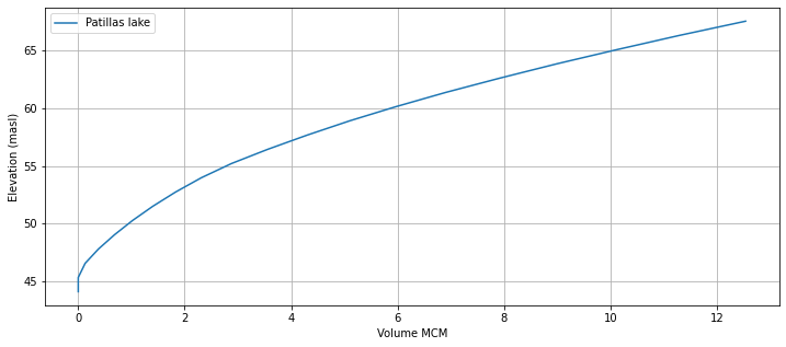
Lake volume in million of cubic meters [0.0, 0.0, 0.13, 0.38, 0.68, 1.02, 1.4, 1.83, 2.31, 2.88, 3.56, 4.3, 5.1, 5.97, 6.91, 7.92, 8.99, 10.12, 11.3, 12.54]
# plot values
fig, ax = plt.subplots(figsize=(12,5))
ax.plot(volArrayMCM,elevSteps,label='Patillas lake')
ax.grid()
ax.legend()
ax.set_xlabel('Volume MCM')
ax.set_ylabel('Elevation (masl)')
plt.show()
# plot values
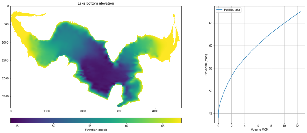
fig, [ax1, ax2] = plt.subplots(1,2,figsize=(20,8),gridspec_kw={'width_ratios': [2, 1]})
ax1.set_title('Lake bottom elevation')
botElev = ax1.imshow(lakeBottom)
divider = make_axes_locatable(ax1)
cax = divider.append_axes('bottom', size='5%', pad=0.5)
fig.colorbar(botElev, cax=cax, orientation='horizontal', label='Elevation (masl)')
ax2.plot(volArrayMCM,elevSteps,label='Patillas lake')
ax2.grid()
ax2.legend()
ax2.set_xlabel('Volume MCM')
ax2.set_ylabel('Elevation (masl)')
plt.show()
Comparison with the USGS survey
From this pu
patVol = pd.read_csv('../Txt/patillasVolume.csv')
patVol.head()

fig, ax = plt.subplots(figsize=(12,5))
ax.plot(volArrayMCM,elevSteps,label='Patillas lake',ls= '-.')
ax.plot(patVol['Storage_capacity_mcm'],patVol['Pool_Elevation_m'],label='Patillas lake - USGS Survey')
ax.grid()
ax.legend()
ax.set_xlabel('Volume MCM')
ax.set_ylabel('Elevation (masl)')
Text(0, 0.5, 'Elevation (masl)')


مدیر سایت: بهزاد سرهادی کارشناس ارشد مهندسی آب
شناسه تلگرام مدیر سایت: SubBasin@
نشانی ایمیل: behzadsarhadi@gmail.com
(سوالات تخصصی را در گروه تلگرام ارسال کنید)
_______________________________________________________
پروژه تخصصی در لینکدین





 در منابع آب















نظرات (۰)